Silvermines 3D model and datasets
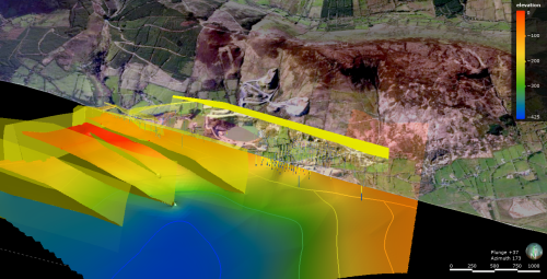
This dataset contains a 3D geological model of Upper Devonian to Lower Carboniferous stratigraphies and faults in the Silvermines area, Co. Tipperary, Ireland. This model is based on surface and underground drilling, mining information including historical mine mapping, as well as geological maps. The model extends 6x3km area down to ~ 500m below sea level. This model was built to constrain the normal fault network controlling the Zn-Pb deposit and to constrain fluid flow pathways.
Download the Silvermines data here.
Methodology
This methodology is also described in Kyne et al. (2019).
3D data were derived from both digital and paper archives, including paper drill logs, limited assays (mainly Pb and Zn with sparse Ag and Cu), interpreted mine plans and sections, as well as surface maps from the literature. We used a combination of Midland Valley’s Move, ESRI’s ArcGIS, and QGIS to digitize and evaluate both data sets prior to being uploaded into the various 3-D modelling packages.
We used Maptek’s Vulcan modelling software to manually digitize surfaces, fault lines, and volumes in areas of densely spaced data (i.e., within the individual orebodies), which has permitted the detailed delineation of various parts of the fault systems and stratigraphic horizons within the two deposits. Once created, these interpreted surfaces, fault lines, and volumes were used as input data for Paradigm’s SKUA-GoCAD modeling software, coupled with Mira Geoscience’s Mining Suite plugins to extrapolate between areas of dense data to create complete fault arrays and horizon surfaces.
To best constrain the normal fault systems within both deposits, and to produce the most accurate fault displacements and geometries, data points contained within individual fault zones were reduced to a single fault surface (i.e., fault plane). Individual fault zones which are composed of fault rock and slip surface bounded, variably deformed host rock lenses, generally occur in decametre (up to ca. 30 m) down to centimetre scales. At this scale, structures cannot be explicitly and fully mapped within 3-D models. In some cases, individual horizon points from drill hole intersections close to fault planes, which are known to be produced by localized inversion on normal faults, were ignored to produce surfaces that are akin to the initial normal fault geometries and pre-inversion displacements.
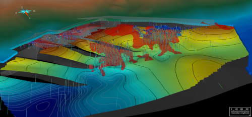
The figure above shows an example of the distribution of drill hole intercepts for the base of the Waulsortian Limestone that was combined with paper cross sections and detailed plan maps to extrapolate a 3D surface for Silvermines.
Publications:
The full modelling methodology and dataset is described in the following two papers:
Kyne, R., Torremans, K., Doyle, R., Güven, J., Walsh, J.J. (2019). 3D modelling of the Lisheen and Silvermines deposits, Co. Tipperary, Ireland: Insights into structural controls on the formation of Irish Zn-Pb deposits. Economic Geology 114(1), 93-116. https://doi.org/10.5382/econgeo.2019.4621
Torremans, K., Kyne, R., Doyle, R., Güven, J., Walsh, J.J. (2018). Controls on metal distributions at the Lisheen and Silvermines deposits: Insights into fluid flow pathways in Irish-type Zn-Pb deposits. Economic Geology, 113(7), 1455-1477. doi.org/10.5382/econgeo.2018.4598
A related iCRAG paper also uses these models to look at fault-controlled fluid flow in extensional basins.
Walsh, J.J., Torremans, K., Güven, J., Kyne, R., Conneally, J., Bonson, C. (2018). Fault-controlled fluid flow within extensional basins and its implications for sedimentary rock-hosted mineral deposits. Society of Economic Geologists Special Publications 21, 237-269. http://doi.org/10.5382/sp.21.11
Terms of use:
These datasets are released under a CC-BY-NC v4.0 licence. Any published work should reference Kyne et al. (2019) and Torremans et al (2018). Where use is made of these data for any purpose, you must acknowledge the material. iCRAG would relish the opportunity to work with you on this data.
The following acknowledgement must accompany the reproduced iCRAG material:
This data uses models and data of the SFI Research Centre for Applied Geosciences (iCRAG) at University College Dublin, licenced under CC-BY-NC v4.0.”
Reproduction of any iCRAG materials does not amount to an endorsement by iCRAG, it’s institutions or any of its employees of any product or service and no such endorsement should be stated or implied.
iCRAG projects involved:
The model was built by iCRAG in 2015-2017 as part of three projects: 3DPlatform, RM.TP1.1 and MODIO, as listed below.
- 3DPlatform: 3D modelling of the Irish Carboniferous Basins from regional down to mineral deposit scale.
- TP1.1.PD1: Structural evolution of Lower Carboniferous faulting and its links to fluid flow and mineralization.
- MODIO: Numerical Modelling of the Structural Controls on Irish Zn Pb Ore Deposits. Funded from the European Union’s Horizon 2020 research and innovation programme under the Marie Sklodowska-Curie grant agreement No. 745945.
Silvermines datasets and models:
General notes and documents Silvermines. [SIL_iCRAG2017_NotesDocs.zip]
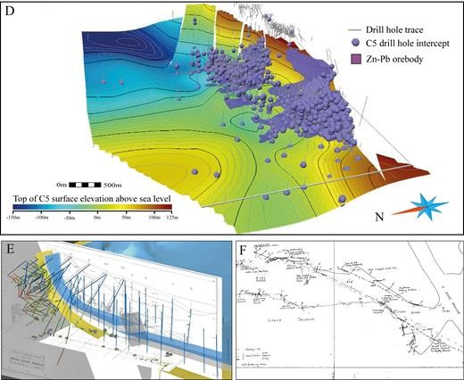
Surface grids of two horizons at the Silvermines deposit. These horizons are the base of the Waulsortian Limestone Fm and base of the Lower Dolomite unit. The Lower Dolomite unit is situated within the Ballysteen Fm. [SIL_iCRAG20170221_Surfaces_Drillholes_Images.zip]
Depth Contoured Maps of the horizons. [SIL_iCRAG20170221_Surfaces_Drillholes_Images.zip]
Drillhole databases for Silvermines. Drillhole database compiled and QA/QCed by iCRAG. This includes collars, survey, geology and assays. The database contains survey and geology information on 2522 drillholes in the Silvermines area in Co. Tipperary, including 46429 assays for Zn, Pb, Cu and Ag (21972 assay intervals). [SIL_iCRAG20170221_Surfaces_Drillholes_Images.zip]
Planar structural data in Silvermines digitized by iCRAG, with 595 fault planes, 562 bedding planes and 125 joint planes. [SIL_iCRAG2017_Digital_Orientation_Data.zip]
Digital georeferenced copies of historical paper copies for 73 Underground mine maps containing geological and geotechnical information, and 376 geological sections (N-S and E-W) in the Silvermines area. Warning: large dataset! [SIL_iCRAG2017_Sections_Plans_Rectified_and_Georeferenced.zip] and [SIL_iCRAG2017_Sections_Plans_Scanned.zip]
LeapfrogGeo 3D model (version 4.2.3) containing the 3D data. [SIL_LIS_iCRAG2017_Leapfrog_Model.zip]
GoCAD 3D model (version 15.5) containing the 3D data and the primary modelling work. [Silvermines\SIL_iCRAG2017_GoCAD_Model.zip]
Other Silvermines iCRAG datasets (these are available for licencing on request and under conditions)
- Georeferenced interpolated drillhole assay maps (geotif)
- Partial asbuilt (*.dxf)
- Vulcan project, containing interpretations of other geological units in addition
- GoCAD 15.5 project, containing interpretations of other geological units in addition
- Arcmap 10 project with project assays
Paper downloads
The full modelling methodology and dataset is described in the following two papers:
Kyne, R., Torremans, K., Doyle, R., Güven, J., Walsh, J.J. (2019). 3D modelling of the Lisheen and Silvermines deposits, Co. Tipperary, Ireland: Insights into structural controls on the formation of Irish Zn-Pb deposits. Economic Geology 114(1), 93-116. https://doi.org/10.5382/econgeo.2019.4621
[Kyne et al 2019 3D Modelling Structural Analysis Lisheen Silvermines.pdf]
Torremans, K., Kyne, R., Doyle, R., Güven, J., Walsh, J.J. (2018). Controls on metal distributions at the Lisheen and Silvermines deposits: Insights into fluid flow pathways in Irish-type Zn-Pb deposits. Economic Geology, 113(7), 1455-1477. doi.org/10.5382/econgeo.2018.4598
[Torremans et al Metal Distribution Lisheen Silvermines.pdf]
and appendices at [Torremans et al Metal Distribution Lisheen Silvermines Appendices.zip]
A related iCRAG paper also uses these models to look at fault-controlled fluid flow in extensional basins.
Walsh, J.J., Torremans, K., Güven, J., Kyne, R., Conneally, J., Bonson, C. (2018). Fault-controlled fluid flow within extensional basins and its implications for sedimentary rock-hosted mineral deposits. Society of Economic Geologists Special Publications 21, 237-269. http://doi.org/10.5382/sp.21.11
[Walsh et al 2018 Fault Controlled Fluid Flow Extensional Basins.pdf]