Geoscience for Leaving Certificate Geography Teachers CPD Programme
About the Geoscience for Leaving Certificate Geography Teachers CPD programme
Geoscience is vital for our sustainable future, and geography is the key gateway to geoscience for most students. The Geoscience for Leaving Certificate Geography Teachers CPD programme has been developed by iCRAG and Geological Survey Ireland to create an opportunity for teachers and geoscience professionals to come together to increase the awareness of geoscience within the Leaving Certificate geography curriculum.
During the CPD course, teachers and geoscience professionals from both research and industry are paired together to co-create curriculum facing resources that are freely available for use. Over the course of six evening sessions, teachers learn more about the cutting-edge geoscience being undertaken by their partnered geoscientists, before working together to develop a curriculum-facing resource using their interests, teaching expertise and the knowledge of the geoscientist.
The course has run twice to date, in 2021 and 2022. The 2023 iteration will begin in October and is open to expressions of interest. If you are a leaving certificate geography teachers, you can express your interest here: https://forms.gle/GfyjT9xjzPaEuopP6
Each year, the resources produced have included lesson plans, module plans and field guides and the accompanying teacher notes and slides/field booklets for each resource.
The resources link the most recent advances in geoscience to the geography curriculum in a way that is both understandable and relevant. The resources are freely available to be used for classes anywhere in the world. We hope that you and your students enjoy using them.
About the Resources
We are incredibly proud of what each cohort of teachers and geoscientists worked together to produce. The resources are listed below with download links. If you are downloading a resource, please consider filling in this form to help us to evaluate the reach of the resources.
Disclaimer: Every effort has been made to ensure that the information in this book is accurate. Data, links, and maps are accurate as of January 2022 (2021 resources) and January 2023 (2022 resources). iCRAG and Geological Survey Ireland cannot accept responsibility for any consequences arising from the use of these resources. iCRAG and Geological Survey Ireland are in no way liable or responsible for any injury or loss to any person using these resources.
| 2022 Resources | |
|---|---|
| Carbon Capture and Storage | Description |
|
|
This resource has been developed by Cian O’Grady, a geography teacher at Calasanctius College, Galway alongside iCRAG scientist Pablo Rodriguez Salgado. The resource examines Carbon Capture and Storage from the Irish Perspective. Included in this resource pack is a full lesson plan and associated teacher notes, and a PowerPoint of slides. It is suitable for Leaving Certificate Students.
Files: CCS Resource - Lesson plan and teacher Notes
|
| Drumlins | Description |
|
|
This resource has been developed by Geraldine O’Brien, a geography teacher at Carrigallen Vocational School and iCRAG researcher Tiernan Henry. The resource is a deep dive into Irish drumlins. Included in this resource pack is a full lesson plan and associated teacher notes, and a PowerPoint of slides. It is suitable for Leaving Certificate Students.
Files: Drumlins - Lesson Plan and Teacher Notes
|
| Folding and Faulting | Description |
-201x284.png) |
This resource has been developed by Seantelle Quane, a geography teacher at St Peter’s Community School School and iCRAG researcher Emma Tomlinson. The resource is a comprehensive overview of folding and folding. Included in this resource pack is a full lesson plan, worksheets and associated teacher notes, and a PowerPoint of slides. It is suitable for Leaving Certificate Students.
Files: |
| Karst Landscapes | Description |
|
|
This resource has been developed by Sinead Burke, a geography teacher at Gort Community School, iCRAG researcher Laurence Gill and geoscience professional Patrick Morrissey. The resource is a deep dive Irish Karst Landscapes. Included in this resource pack is a full lesson plan and associated teacher notes, and an ArcGIS Storymap. It is suitable for Leaving Certificate Students.
Files: Karst Landscapes - Lesson Plan and Teacher Notes
|
| Mining in Ireland | Description |
|
|
This resource has been developed by Eleanor Solon, a geography teacher at Hewitt College, Cork and iCRAG researchers Aileen Dolan and Phil Rieger. The resource is a deep dive into the contentious topic of mining in Ireland. Included in this resource pack is a full lesson plan and associated teacher notes, and a PowerPoint of slides. It is suitable for Leaving Certificate Students.
Files: Mining in Ireland - Lesson Plan and Teacher Notes
|
| 2021 Resources | |
| Geothermal Energy Module | Description |
|
|
This resource has been developed by Elaine Egan, a geography teacher at Synge Street CBS, alongside geoscience professionals Rory Dunphy and Koen Verbruggen, both from Geological Survey Ireland. The resource is a deep dive into geothermal energy, covering at least four lessons. Included in this resource pack is a full module plan and associated teacher notes, and a PowerPoint of slides. It is suitable for TY students as well as Leaving Certificate Students.
Files: Geothermal Energy Module - Module Plan and Teacher Guide Geothermal Energy Module - Slides Evaluation form |
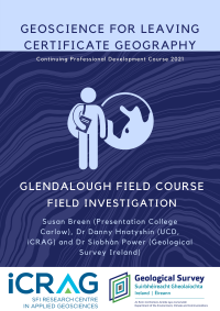
| Glendalough Field Study | Description |
|
|
This resource has been developed by Susan Breen, a geography teacher at Presentation College Carlow, alongside geoscience professionals Dr Danny Hnatyshin from iCRAG at UCD and Dr Siobhán Power from Geological Survey Ireland. This resource is a field guide and accompanying teacher guide for a field investigation of Glendalough, Wicklow. The field investigation covers the geology of the area, alongside considering the historical and human importance of the site. It has been designed for Leaving Certificate students but may be suitable for younger students with some additional preparation.
Files: Glendalough Field Course - Fieldwork Plan and Teacher Guide |
| Volcanic Activity in the Irish Context | Description |
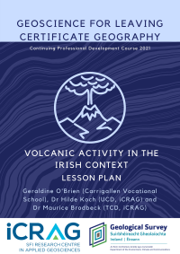 |
This resource has been developed by Geraldine O’Brien, a teacher from Carrigallen Vocational School and Drs Hilde Koch and Maurice Brodbeck from iCRAG at UCD and TCD respectively. This resource is a lesson plan for at least a double lesson that investigates volcanic activity from the Irish context. It has been designed for Leaving Certificate Students.
Files: Volcanic Activity in the Irish Context - Lesson Plan and Teacher Guide |
| What Lies Beneath? (An introduction to geoscience) | Description |
 |
This resource has been created by Jennifer O’Sullivan from Killorglin Community College alongside geoscience professionals Dr Tiernan Henry from iCRAG at NUIG and Dr Eamon Doyle from the Burren and Cliffs of Moher UNESCO Global Geopark. This is an introductory resource for classes just starting their geoscience learning journey. It is aimed for a double class and is suitable for Leaving Certificate level students, though younger students may also benefit from this resource.
Files: |
| Irish Geohazards: How we monitor and mitigate them | Description |
 |
This resource has been created by Eileen Kelley from Castleknock Community College, alongside geoscientists Drs Eve Daly and Haleh Karbala Ali both from iCRAG at NUIG and DIAS respectively. This resource examines the geohazards that affect Ireland, such as groundwater and flooding, and investigates the methods we use to monitor the hazards and mitigate for their potential effects. This resource has been designed to cover at least a double class and is suitable for Leaving Certificate level students.
Files: Irish Geohazards: How we monitor and mitigate them - Lesson Plan and Teacher Guide |
| Seismic Activity |
Description |
_web.png) |
This resource has been created by Claire Healy, a geography teacher from Douglas Community School in County Cork, and Drs Srikumar Roy and Pablo Rodriguez-Salgado, both from iCRAG at UCD. This resource is a full module that examines seismic activity in depth. The resource covers everything from the basics of seismicity to the tsunamis that have threatened Ireland in the past. It has been designed as a Transition Year module, but aspects are suitable for Leaving Certificate classes.
Files: Seismic Activity Module - Module Plan and Teacher Guide Seismic Activity Module - Slides Evaluation form |
-200x283.png)
(1)_web-201x284.png)